Narwhal Pursuit of Halibut to the Bottom of Baffin Bay
Part 5. The Narwhals' Tale of Rising Seawater and Sinking Ocean
Due to a shrinking ice cap, the Arctic Ocean has twice the open seawater; therefore, greater volumes of water freeze in the fall. When ice forms, salts concentrate in the adjacent liquid. The water around the floating ice becomes saltier. Very cold and denser, it sinks. This pumping action of more deep water puts more energy into the thermohaline circulation to strengthen it.
The Gulf Stream transports warm water northwards at a velocity ranging between 85 to 105 sverdrup (1 sverdrup = 106 cubic meters per second). The Amazon River, the largest river in the world, carries 0.2 sverdrup. The Gulf Stream is five times stronger than the AMOC!
More seawater was observed coursing the Gulf Stream in October 2011 when the intensified Stream meandered in a deeper curve, swinging further northwest up onto the continental shelf. For a couple of months, the Gulf Stream sped closer to Rhode Island than ever before. The Gulf Stream is like a river that gains much energy cascading down a mountain. When the water’s descent is stopped by hitting a plain, the energy must go somewhere rapidly. Energy must dissipate, and so the river meanders. With more volume and energy, it curves back and forth instead of flowing in a straight line. The greater the river’s departure from the straight and narrow, the greater its “sinuosity,” as it gives up potential energy. Viewed from a distance on high, the river's course can remind one of a freight train crash, dissipating energy by sending cars every which way.
The Gulf Stream is forced to accelerate through the Florida Straits. More water volume through the Straits results in more energy being released. This water energy, the potential-vorticity budget, is spent on the structural distortion of flow in a meander compared to the straight portion. Meanders bunch up and circle back to cut off, forming “ox-bows,” warm-core eddies that spin westerly, and cold-core eddies that drift east into the Sargasso Sea. The unprecedented large meander onto the Continental Shelf off Rhode Island indicates more warm water in the Gulf Stream barreling north to the Arctic Ocean.
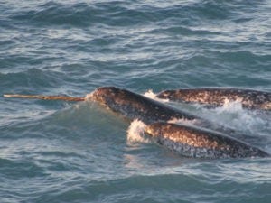
Narwhal pod Photo Kristin Laidre
This brings us back to the narwhals mentioned at the beginning of this tale. They live and carry out their sophisticated monitoring processes on the threshold between the Arctic and Atlantic Oceans.
Baffin Bay, located to the west of Greenland, is an arm of the Atlantic Ocean. Here, there are three water masses. Arctic Water is near the top. West Greenland Intermediate Water is in the middle, and Deep Baffin Bay Water is in the deepest basins. The surface water on top was found to have a thermocline at a depth of less than 300 feet. This indicates the extent of the downward reach of air and land-runoff temperatures, as only the surface waters change with the weather.
The Baffin Bay is often not the calmest water for ocean research, as Kristin Laidre and her intrepid researchers discovered the hard way. The nimble bathythermograph has been replaced by a multitude of horizontal Nansen-like bottles attached to a large metal frame called a rosette. The conductivity-temperature-depth instrument, the CTD, works on the principle that seawater conducts more electricity when denser. The CTD-Rosette is lowered from a worm-gear hydro winch that carefully pays out the cable. Much cable is needed. The average depth of Baffin Bay is 3,000 feet. The depth of the deep basin known as Baffin Hollow is 7,008 feet. It takes many hours to sample the three-layered water column all the way down.
To find evidence of seawater warming in Baffin Bay, researchers found historical data sets collected between 1950 and 2003. Bottom water temperatures exhibited statistically significant warming at depths between 1,300 and 7,000 feet. The maximum warming was found in a water mass between 2,000 and 2,600 feet. This warming of Intermediate Water was as large as 0.2°C (0.36°F) per decade.
Given the challenges of deploying CTD Rosette water trapping arrays over the side of a ship and the amount of sea ice in Baffin Bay that could wreak havoc to a ship tethered for the better part of a day by hydro-winch cable to gear over the side, researchers turned to the local narwhal population for assistance.
Narwhals dive to the ocean floors of Baffin Bay ten to twenty-four times a day for Greenland halibut. Fourteen narwhals were captured and fitted with satellite‐linked time‐depth‐temperature recorders. When they surfaced, data was transmitted to the researchers. CTD-Rosettes were used from ships and helicopters to verify the accuracy of the whales' findings.
One of the deepest diving cetaceans in the world, narwhals proved to be excellent “ocean samplers.” Dives lasted more than twenty-five minutes. Given the distance underwater involved, dives were vertical. Deep vertical dives are ideal for repetitive depth and temperature casts. Narwhals also favor diving for fish beneath Arctic offshore ice. For obvious reasons, few oceanographic studies have been done in these areas. Much of Baffin Bay is covered by ice in various forms throughout the summer.
Tags put on narwhals in August and September lasted up to seven months before falling off. Data was transmitted with every surface and every breath of the whales. Data was collected well into the winter months.
Narwhals documented that the surface water, which was in contact with the overlying sea ice cover, was thinning. The thermocline had moved up, and the surface water was less deep than previously observed, at 160 to 260 feet. Beneath this relatively cool water is a much larger, warmer water mass, the West Greenland Intermediate Water. Narwhals found that the depth of cool surface water is lessening, and warmer waters below are expanding upwards.
Next: The Narwhals' Tale of Rising Seawater and Sinking Ocean
Part 6, Jetting through the Denmark Straits and the Labrador Current Home


