

Jetting through the Denmark Straits and the Labrador Current
Part 6: The Narwhals' Tale of Rising Seawater and Sinking Ocean

Southbound seawater from the Arctic Ocean, powered by differing water densities of thermohaline circulation, flows into the Greenland Sea. Beyond is the Denmark Strait between Iceland and Greenland. This is the gateway to the Atlantic Ocean, where the current narrows into a “jet” of higher energy flow, the place that the Woods Hole Oceanographic Institute calls the “superhighway.”
Cold, nutrient-rich Arctic water crashes into the bulwark of warmer Atlantic Water. Deflecting energy, Arctic water plunges downwards into the Denmark Strait Cataract. The world’s largest waterfall plunges one-hundred-seventy-five million cubic feet of water per second, about 2,000 Niagara Falls, 11,500 feet down, three times the height of Angel Falls in Venezuela, to form the East Greenland Intermediate Water.
Greenland Intermediate Water barrels south between the King Frederick VI Coast of eastern Greenland and the Reykjanes Ridge, the portion of the Mid-Atlantic Ridge south of Iceland, the seam of the spreading Atlantic. At Cape Farewell, where ragged black slates and schists tower 2,000 feet above the southern tip of the world’s largest island, the ocean current, influenced by the Coriolis effect with a centrifugal motion, veers right to wrap the shore and flow northwest along Greenland’s western shore.
On the Cape Farewell Ground, two to four hundred miles south of Greenland, five stationary hydrophones were deployed to listen for whales. The North Atlantic right whale has a distinctive “up whoop” call like no other whale. Shifting through the cacophony of ocean sounds from July to December 2007, researchers identified more than 2,000 calls of right whales. They think at least three whales, maybe more, were heard. Two right whales have been sighted on Cape Farewell Ground for the last fifty years. One whale was recognized by its callosity pattern and scars and has rarely been seen in the population of the Gulf of Maine. The other right whale was unknown to researchers. This gives hope that there are more right whales than we know visiting the Labrador Sea off Greenland.
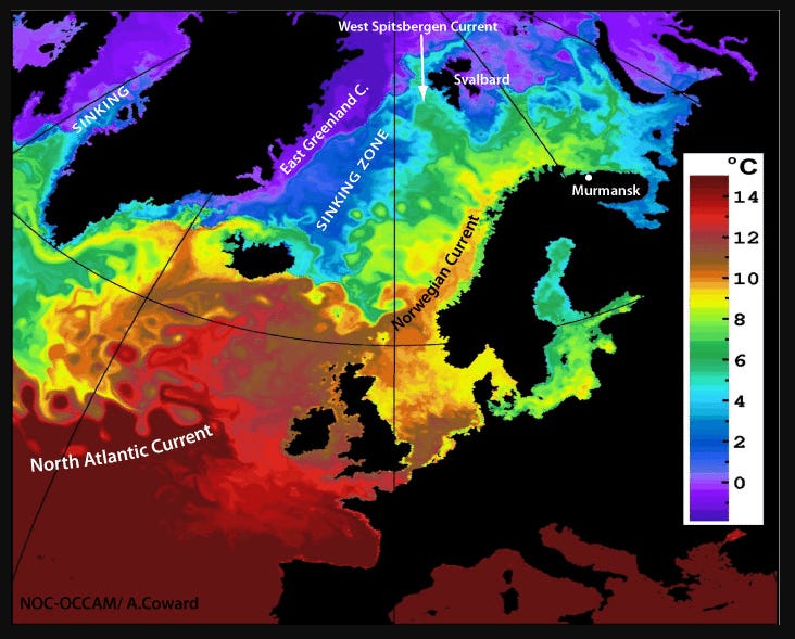
Image: Major ocean currents in the North Atlantic and associated sea surface temperatures. 559 (Source: NOC/UK Met-Office OSTIA data; map from http://www.seos-project.eu ) 560 561 562
The West Greenland Intermediate Water flows north through the Labrador Sea into Baffin Bay, passing Nuke, Greenland’s capital. There, the water makes a “U” turn. The southbound water moves through the Davis Straits at about one mile per hour. Entering the Labrador Sea, the water mass mixes and increases in volume with the colder and less salty Baffin Island Current to become the Labrador Current. Nutrient-rich waters from the Arctic are enhanced with nutrient-rich waters from Russian and Canadian rivers, including the Mackenzie River, second in size only to the Mississippi in North America—the combined current flows southeast at 7.6 sverdrup or 7.6 million cubic meters per second (268 million cubic feet per second). Transporting icebergs, the Labrador Current is a legendary hazard for ships. Off Newfoundland's craggy, steep-sided coast, the traveling water mass veers right in a southwesterly direction.
On to the Flemish Cap, a 12,000 square mile international fishing bank. Before the Cap, the Current splits right to pass through the Flemish Pass Basin next to Newfoundland and left to flow outside the cap in deep water over the Sohm Abyssal Plain. The nutrient-rich waters of the Labrador Current pass below nutrient-poor warmer waters transported north by the Gulf Stream. Heavy fog arises when the cold air of the land meets warm water. The layering of the northbound Gulf Stream over the southbound Labrador Current creates one of the richest fishing grounds in the world.
The Labrador Current traverses the Scotian Shelf. A portion enters the Gulf of Maine through the Northeast Channel, a sixty-mile-wide deep-water passage between Browns Bank off Cape Sable and Georges Bank off Cape Cod. Much of the Labrador Current brings nutrients along the southeast side of Georges Bank before flowing south towards the Equator,
The volume of Labrador Current water entering the Gulf of Maine varies unexpectedly from year to year. As we say, the barn door is open, the barn door is closed, or the barn door is ajar. The less Labrador Current Water enters the more Continental Slope Water floods into the Gulf of Maine. This happens beneath Continental Shelf Water and beneath surface waters during spring and summer.
Capelin fish and sand lance are most abundant in Labrador Current water. These fish are foraged by demersal or ground fish, including cod, haddock, and halibut. An increase in the volume of Labrador Current water entering the Gulf of Maine brings nutrient and oxygen-rich water that positively impacts marine life and the food chain, including populations of commercially valuable fish and squid.
Clearing the Northeast Channel into the Gulf of Maine, the Labrador Current spills into Georges Basin, north to Jordan Basin, and counterclockwise to the west into Wilkinson Basin. The cold Labrador Current deposits the last waters from the Arctic beneath the Western Maine Coastal Current in Bigelow Bight off the sandy shores of Plum Island, Massachusetts, and Rye Beach, New Hampshire.
Within the Gulf of Maine are three distinct large bodies of saltwater. In the deep portions of the Gulf, there is Labrador Current Water. Warmer Slope Water covers the Labrador Water. Higher in the water column is Continental Shelf Water. This water body spreads out over the banks. Thus, the Gulf of Maine is a “salinity sandwich” with fresh surface waters on top. Cold, dense nutrient-and-oxygen-rich waters from the Labrador Current on the bottom and Continental Shelf and Slope Waters layered in between.
In Baffin Hollow, narwhals have parted water that may later settle in the three basins of the Gulf of Maine. They surprised us with unexpected measurements of the ocean’s capacity to absorb heat from climate change. Warm intermediate water expanded skyward towards surface waters. The water temperature and density of ocean currents have not changed, but the volume and flow of ocean currents have increased.
When we remove vegetation and soil on the land, leaving only dirt, the land hardens and warms to become a heat island. Warm surfaces heat rainwater that becomes stormwater rushing to the sea. The water is fresh and less dense than ocean water, so it spreads out over the surface. During the summer of 2021, Boston experienced nearly four degrees above average summer temperatures. Yet surface ocean temperatures stayed average. In 2023, summer air temperatures were average, but surface ocean temperatures increased by nearly two degrees Fahrenheit because Boston had experienced the most rainfall since 1955.
Watch NASA’s 1-minute animated video of the West Spitsbergen Current melting Arctic Ice.
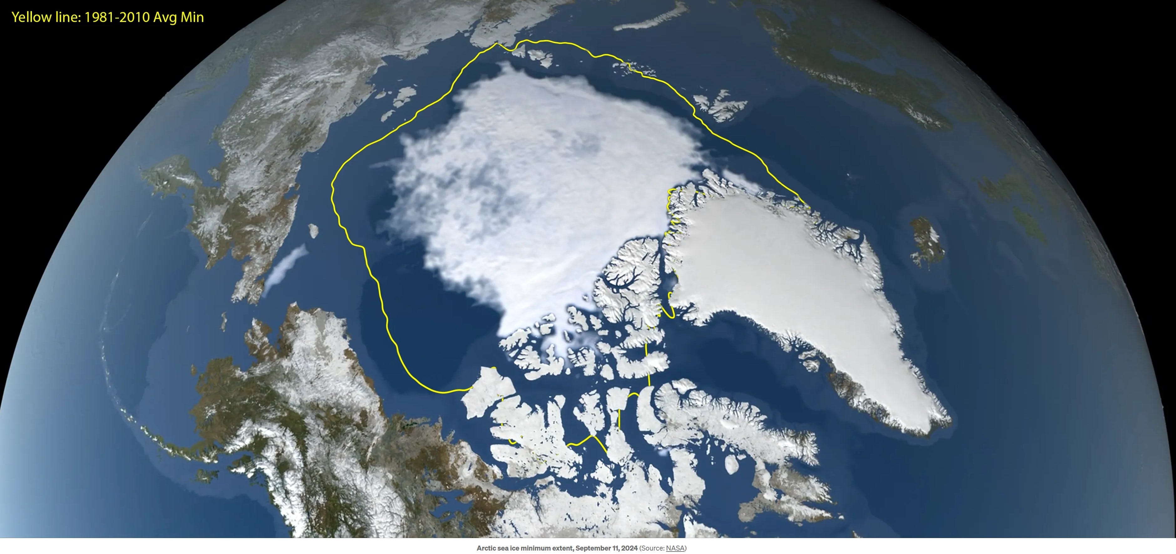
In the Arctic, sea ice does not melt like the spring thaw of ice on a lake that starts along the shore and leaves a patch of ice in the middle. Instead, the melt begins against the Greenland Sea and not the land. The West Spitsbergen Current transports more warm Atlantic Water into the Arctic Ocean. NASA imagery of the 2024 sea ice melt shows it following the ocean currents’ counterclockwise gyre until the thickest ice remains at the current’s farthest reach along Canada and Greenland’s shore.
The ocean near my home, below the thin surface water layer, is not warming faster than other places. Its thermodynamics are not unique, nor is climate change selective. It is connected, part of the planetary whole, with one ocean covering 71% of Earth. The marvelous blue merry-go-round with surface and deep water currents going up and down around the world about every 1,000 years, give or take a few hundred. Our respect for the ocean is advanced when we better understand the water movements, bounded by density, temperature, and salinity, driven by ice formation, carrying nutrients toward the equator and heat to the poles.