


Captain Scoresby’s Ten-gallon Fir-Cask in the Greenland Sea

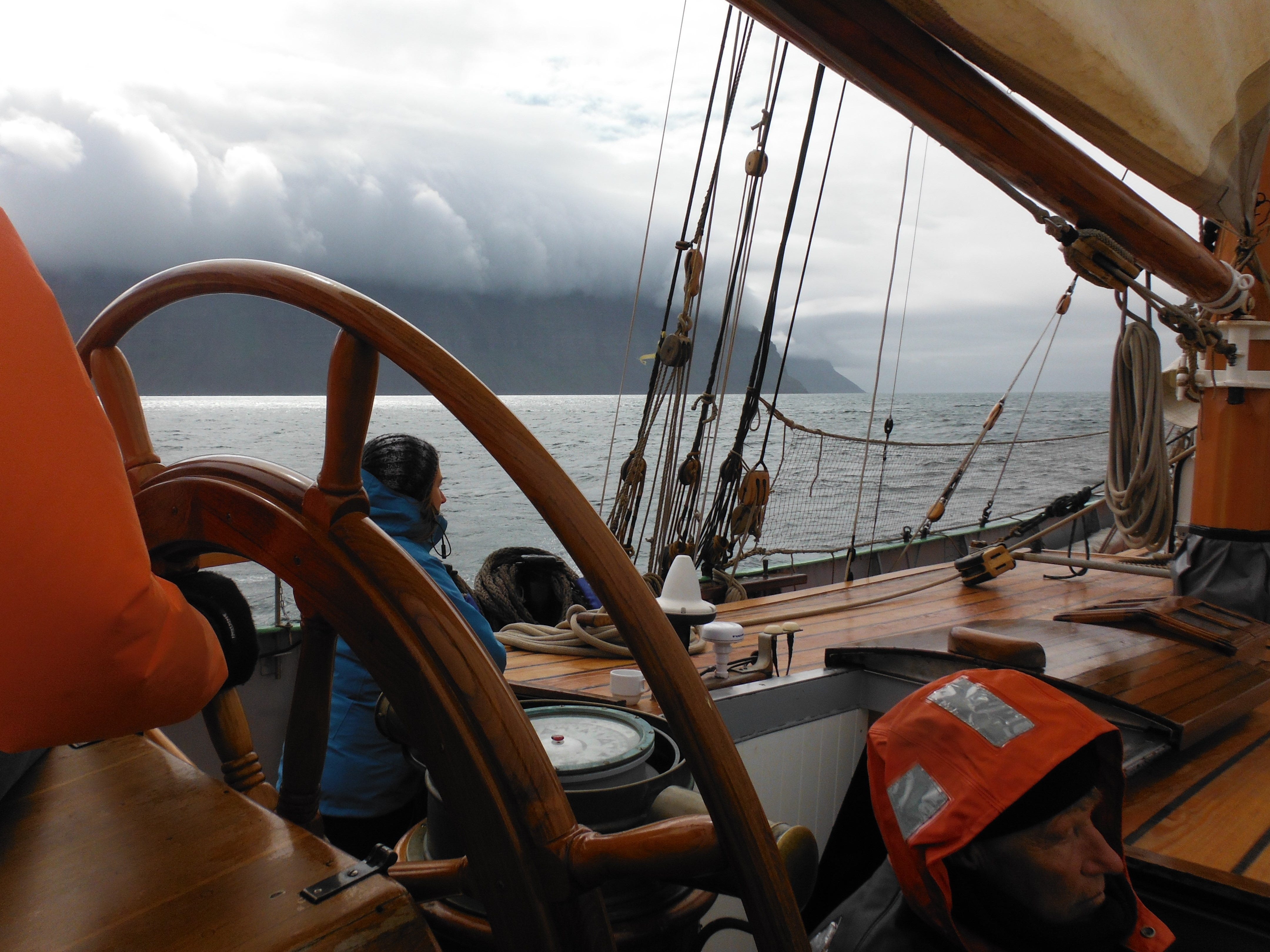
In 1810, in the Greenland Sea, William Scoresby Jr., the captain of Resolute, who was 21 years old, used an oceanographic instrument made from a ten-gallon wooden cask. It was built following Lord Joseph Banks's instructions. The cask was made of two-inch-thick fir planks, “as being a bad conductor of heat.” At each end of the cask was a valve connected by a wire that opened and closed at the same time—a horizontal lever with a flat circular paddle extended from the barrel. When lowered, the lever was pushed upward, opening the valves and allowing seawater to flow through the barrel. When the hydrowinch was braked and the barrel stopped descending, its gravity caused the valves to close. The paddle lever kept the barrel sealed as it was reeled up from the ocean depths.
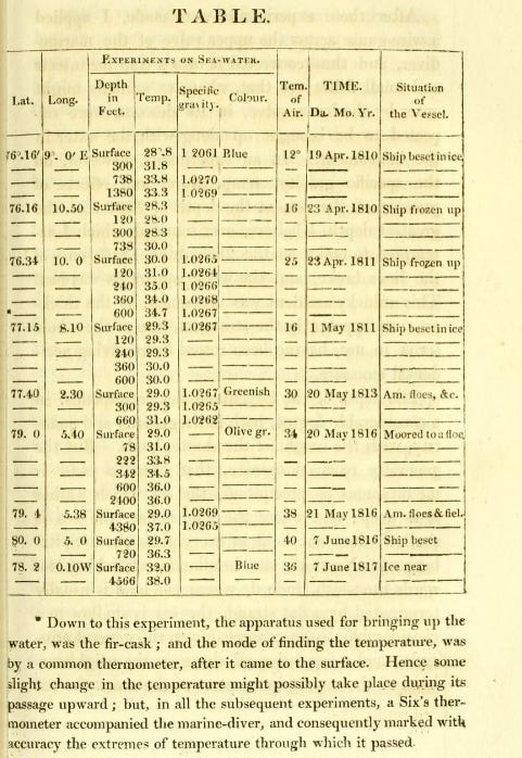
Scoresby first deployed the fir-cast on April 19, 1810. The Resolute was described in the data table as a “ship beset in ice.” They were in the Greenland Sea, west-southwest of Svalbard at Latitude 76.10’ North and Longitude 9.0’ East. The conventional wisdom was, and remains for many today, that the ocean is like a big bathtub where the temperature you feel with your toe correlates to the temperature down in the water column. If anything, the water would become colder with depth due to increasing distance from the surface and increasing density with rising pressure from the column of water above.
Preparing to lower the fir-cask, it was noted that the surface ocean water was blue and 28.8 degrees F. The cask was lowered to a depth of 300 feet, where water was trapped, then raised and brought back onboard. The water was surprisingly 31.8 degrees. A deeper sounding, to 738 feet, showed seawater at 33.8 degrees. Finally, from a depth of 1,380 feet, the seawater measured 33.3 degrees. The water below the cold surface waters was warmer.
Initially, they blamed the common thermometer inserted into the cask on the deck. Later, a minimum-maximum thermometer was installed inside the cask behind a glass pane to avoid disturbing the contents when measuring the temperature. Water temperatures at different depths were measured multiple times from April to May 1810 and again in 1811, with similar results.
From the fact of the sea near Spitsbergen being usually six or seven degrees warmer at the depth of 100 to 200 fathoms than it is at the surface, it seems not improbable that the water below is a still farther extension of the Gulf Stream, which, on meeting with water near the ice lighter than itself, sinks below the surface, and become a counter under-current. (William Scoresby, page 209.)
The ship Resolution was close to directly over the deep suture fault line where the North American plate diverges from Europe. Scoresby was making observations in Fram Strait, the only deep-water connection between the Arctic Ocean and the World Ocean. The fir-cask was capturing warm water transported North by the Gulf Stream. The Gulf Stream warmed Scotland’s Western shores, permitting palm trees to grow. Across the Atlantic, North American shores are chilled by the cold Labrador Current, transporting ice from Baffin Bay and Greenland. Scoresby noted: “a body of about 2000 square leagues of ice, having drifted out of the Greenland Sea.”
Scoresby was also concerned with climate change, writing: “changes of climate to a certain extent, have occurred, within the limits of historical record; these changes have been... considered as the effects of human industry, in draining marshes and lakes, felling woods, and cultivating the earth.” (page 263)

Two hundred years later, the climate changed as the Gulf Stream strengthened. In 2007, warm Atlantic Gulf Stream water rose to the surface of the sea at Svalbard, warming the air and melting the glaciers on the islands. 2 By 2011, the Gulf Stream was observed meandering to dissipate energy onto the Continental Shelf closer to Rhode Island than ever before. 3 NASA’s Arctic Sea Ice Minimum 2024 animated video shows the Arctic Ocean first melting where the Atlantic meets the Arctic and then moving counterclockwise along Siberia’s shore because of the Earth’s spin, which causes flowing water to turn to the right— the Coriolis effect. 4

Sea ice forms to cover the Arctic Ocean in October. Water freezes at a warmer temperature if it is fresh. As water solidifies, salt is extruded into the adjacent liquid. Scoresby reports: “With the degree of saltness common to the Greenland Sea, freezes at 28 ½. Seawater, concentrated by freezing, until it... requires a temperature of 13 2/3 for its congelation, having its freezing point reduced by 18 1/3 below that of pure water.” (page 231)
In 2005, researchers reported that in Svalbard, ice formation and brine rejection had created the highest bottom salinities observed in the last 20 years.5
The cold, briny water of the Arctic Ocean sinks and increases the flow of nutrient-rich Arctic water out of Fram Strait into the Atlantic Ocean. It jets through the Denmark Strait, gaining energy from the squeeze between Greenland and Iceland. Meeting warm nutrient-poor Atlantic water, it once dove 11,000 feet to flow below. With the increased volume of Arctic water, the dive may not go as deep. Further south, a cold-water temperature anomaly has formed, similar to the puddle at the bottom of a slide, known as the Cold Blob.
Meanwhile, since Scoresby’s voyage, “the effects of human industry, in draining marshes and lakes, felling woods, and cultivating the earth” have accelerated the removal of vegetation and soils, and the loss of the carbon sponge, while increasing the extent of hard, impervious surfaces. Without increasing annual rainfall, rainwater that once infiltrated the ground now becomes destructive stormwater warmed as it crosses hardscapes before crashing into the sea. We have strengthened the Gulf Stream with stormwater, which is transporting more water northward to warm the Arctic and melt more sea ice during summers.
Water vapor is a greenhouse gas that traps heat. The more moisture, aka humidity, that is held in the atmosphere, the more heat energy is available to power storms. A recent Science publication found that of the 1.5 degrees Kelvin temperature increase the world has experienced, 0.2 degrees, or 11%, was due to carbon dioxide emissions. In comparison, 1.2 degrees, or 80%, was caused by water vapor. 6
When sea air laden with moisture passes over coastal hardscapes and heat islands, the air is warmed, expands, and becomes thirsty for more water. Researchers have estimated that drying air has pulled more than a Lake Huron volume of moisture from the world’s soils, drying them out. 7
Increasing soil moisture and vegetation is eight times more effective at reducing climate change than cutting carbon dioxide emissions because there is eight times the volume of water vapor compared to carbon dioxide. If we could increase vegetation and soil by a few percentage points, Earth would experience fewer adverse effects from 420 parts per million of carbon. Naturally, enhanced photosynthesis and a more active water cycle would also help to dramatically decrease the atmospheric carbon burden by drawing from the approximately 800 billion tons of carbon dioxide in the atmosphere and adding to the approximately 2,800 billion tons of carbon in soils. A more comfortable 350 ppm carbon dioxide level in the atmosphere is equivalent to 700 billion tons.
The lesson of the ten-gallon fir-cask is that if you want to understand how the world works and improve conditions for life, it’s best to venture out with a hardy crew and practice the real science of observation, recording, questioning, and communicating. Look deep below the surface, and when the data defies one's beliefs, let go of the dogma and figure out what the world is telling you. And we’ll all be glad you did.
References:
1. Scoresby, William. An account of the Arctic regions with a history and description of the northern whale-fishery. 1820 https://archive.org/details/accountofarcticr01scor/page/184/mode/2up
2. The sea and ocean currents - nettarkiv.npolar.no https://nettarkiv.npolar.no/www.arcticsystem.no/en/outsideworld/oceancurrents/index.html
3. Bert Rudels, Göran Björk, Johan Nilsson, Peter Winsor, Iréne Lake, Christian Nohr. The interaction between waters from the Arctic Ocean and the Nordic Seas north of Fram Strait and along the East Greenland Current: results from the Arctic Ocean-02 Oden expedition, Journal of Marine Systems Volume 55, Issues 1–2, March 2005. https://www.sciencedirect.com/science/article/abs/pii/S0924796304002015
4. NASA Arctic Sea Ice Minimum 2024. September 24, 2024 https://svs.gsfc.nasa.gov/5382/
5. Bert Rudels, Göran Björk, Johan Nilsson, Peter Winsor , Iréne Lake , Christian Nohr. The interaction between waters from the Arctic Ocean and the Nordic Seas north of Fram Strait and along the East Greenland Current: results from the Arctic Ocean-02 Oden expedition, Journal of Marine Systems Volume 55, Issues 1–2, March 2005, Pages 1-30 https://www.sciencedirect.com/science/article/abs/pii/S0924796304002015
6. H. F. Goessling, T. Rackow, T. Jung, Recent global temperature surge intensified by record-low planetary albedo. Science 387 (6729), 68–73 (2024), https://doi.org/10.1126/science.adq7280
Seo, et al. (2025, March 27). Abrupt sea level rise and Earth’s gradual pole shift reveal permanent hydrological regime changes in the 21st century. https://www.science.org/doi/10.1126/science.adq6529
Hi Rob, Walter Jehne a retired Australian soil scientist noted that as west Australian wheat belt expanded the rain bearing cloud belt moved with the edge of the forested area. He put this down in part to the precipitation nuclei produced by the forest. https://regenerate-earth.org/ A lot can be said about the adverse impacts of our land management practices not only on ground water but on atmospheric chemistry.
have been giving some thought to cumulonimbus cloud spires as energy release valves and their input into temperature release of water vapor latent heat above other cloud masses to be reflected back into space. The notion that If you can create a ladder of ice nucleation due to higher to lower nucleation particles you should be able to cause the biotic pump effect at higher and higher altitudes but if we destroy the lower rungs of the ladder can clouds climb the ladder? I would love to see if anyone has done a study in relation to vegetation types or more importantly nucleation types and cloud effects . studies in the past show a warm influx creating an upwelling but could cloud height be a property of ice nucleation? and how does this feed into heat radiation? especially above the low cumulous cloud mass.